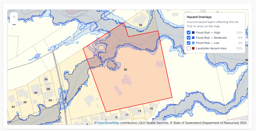
To run a flood check by address, open your state’s flood overlay map and switch on each hazard layer, or search the address once in PlanInsight and read the Hazard Overlays section: every flood, bushfire, landslide or coastal overlay crossing the lot, with the share of the lot it covers. Then download a flood overlay DXF with each hazard on its own layer, lined up with the boundary and contours.
Why check the hazard overlay early
Flood planning areas bring floor levels and flood studies. Bushfire prone land brings a BAL assessment. Landslide and acid sulfate soils bring geotechnical work. Find them before the fee proposal.
Hazard overlays by state
Each state’s viewer, and what PlanInsight checks there:
- QLD (QLD Globe): Floodplain Assessment Overlay (the statewide flood overlay map QLD publishes), Bushfire Prone Area, storm tide inundation and erosion prone areas. Brisbane, Gold Coast, Sunshine Coast, Moreton Bay and Logan overlays replace the statewide layer, so a flood overlay for Brisbane or the Gold Coast comes from council mapping. Brisbane, Sunshine Coast and Moreton Bay add a landslide overlay and acid sulfate layers.
- NSW (Planning Portal viewer): Flood Planning Area, Bush Fire Prone Land (the NSW bushfire overlay map), Landslide Risk Land, Acid Sulfate Soils and coastal management areas, which are not a hazard map.
- VIC (VicPlan): LSIO, Floodway Overlay, Special Building Overlay, Bushfire Management Overlay (BMO), Designated Bushfire Prone Area, Erosion Management Overlay.
- SA (SAPPA): Hazards (Flooding) and (Bushfire) overlays, coastal overlays, acid sulfate soils.
- WA (PlanWA): Floodway, Flood Fringe, Bush Fire Prone Area, acid sulfate soil risk.
- TAS (theLIST): Flood-Prone Areas, Bushfire-Prone Areas, landslip and coastal erosion hazard bands.
- ACT (ACTmapi): 1% AEP Flood Extent, Bushfire Prone Area.
- NT: no hazard overlays; no queryable service is published.
By hand, you check each layer by eye and trace a screenshot for CAD.
Check hazard overlays in PlanInsight
- Search. Type the address into Address under Quick Search and click Look Up Property, or use Property Lookup.
- Open Hazard Overlays. A summary appears, such as “Affected by 2 of 6 hazard overlays”.
- Read the list. Each affected overlay shows its coverage, e.g. “38% of lot”. Failed sources sit under Unavailable right now, so a missing result never looks clear.
- Check the map. Click a row to toggle that overlay on the property map.
- Export. Click Download DXF; the Hazard Overlays group is ticked by default. Click Download.
See the hazard overlays page for full coverage.
Get the flood overlay DXF into CAD
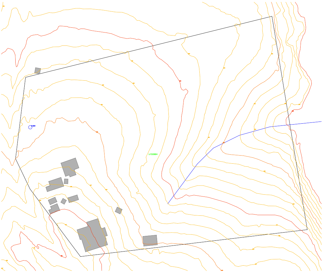
Each type gets its own layer plus a _FILL layer: OVERLAY_FLOOD_PLANNING (with OVERLAY_FLOOD_HIGH/MODERATE in VIC and WA), OVERLAY_BUSHFIRE, OVERLAY_LANDSLIDE, OVERLAY_ACID_SULFATE, OVERLAY_COASTAL. Polygons are labelled and clipped to the lot plus a margin.
The file is DXF R12, in metres, in local coordinates, not MGA. To combine with a survey, MOVE or ALIGN onto surveyed boundary corners.
“% of lot” is a scoping number, and mapped overlays are not certificates: use the council’s flood search or planning certificate for approvals.
Is there an overland flow map for my lot?
Not always. A lot outside the flood overlay can still take overland flow, so read the contours and WATERCOURSE layer too. See the stormwater feasibility workflow.
How do I find the bushfire prone land map for my address?
Search it in your state viewer above, or in PlanInsight to see bushfire, flood and landslide together. Every layer is on every plan, with a 14-day free trial, no credit card. Only need the boundary? The free boundary tool needs no account.