A flood overlay is a planning control. It is a mapped area in a planning scheme where the council has decided flooding is a constraint, so extra rules apply to building and subdivision there. It is not a prediction that your land will flood, and it is not a flood certificate. It is a trigger.
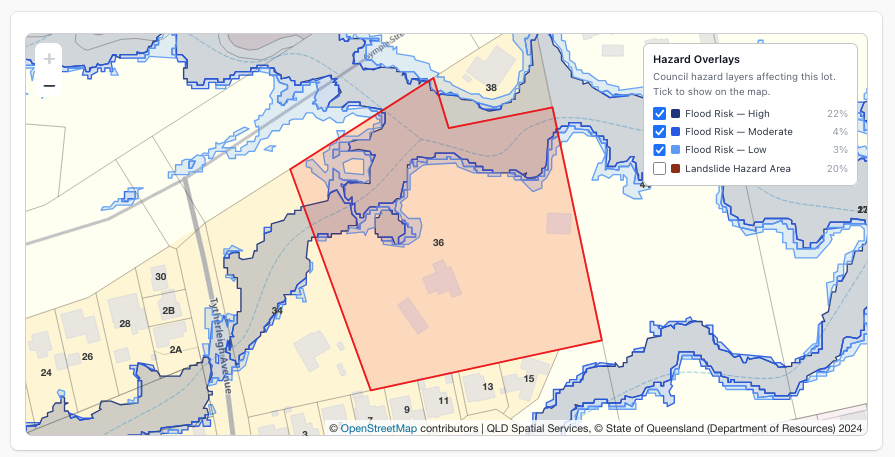
What does a flood overlay mean for a site
Three things, in order of how much they cost you.
- A permit or a code assessment. Work that would otherwise be exempt often needs approval inside a flood overlay. In some schemes a single dwelling moves from code assessable to impact assessable, which changes the timeline by months.
- A minimum floor level. The council sets habitable floor levels relative to a defined flood level, usually the 1% AEP level plus freeboard. This drives the whole design: slab height, driveway grades, step down to garages, accessible entry.
- A flood study or hydraulic assessment. For anything beyond a modest dwelling, the council asks for a report showing no worsening of flood behaviour on neighbours. That is a specialist fee, and it needs levels and design rainfall before it can start.
What a flood overlay does not mean is that the land floods in every storm, or that it floods at all. Overlay boundaries are modelled, mapped at a scale, and often deliberately conservative. A lot can sit inside the overlay and have its building envelope well above the flood level.
And the reverse matters more. Land outside the flood overlay can still flood. Overland flow, the water that sheets across a property on its way to a pipe or a creek, is mapped in some councils and not in others. If the contours show your site at the bottom of a catchment with no mapped overlay, believe the contours.
What each state and territory calls it
The concept is the same everywhere. The name is not, which is why searching for “flood overlay” in some states returns nothing useful.
- Queensland: the Flood Hazard Overlay or Floodplain Assessment Overlay. The statewide layer applies where a council has not mapped its own. Brisbane, Gold Coast, Sunshine Coast, Moreton Bay and Logan map their own and those replace the statewide layer.
- New South Wales: the Flood Planning Area, with the flood planning level set in the LEP and the council’s flood study. A section 10.7 planning certificate states whether the land is flood affected.
- Victoria: the Land Subject to Inundation Overlay (LSIO), the Floodway Overlay (FO) and the Special Building Overlay (SBO). The SBO is the overland flow one, mapped by the drainage authority.
- South Australia: the Hazards (Flooding) overlay in the Planning and Design Code, plus the general flooding overlays.
- Tasmania: Flood-Prone Areas under the state planning provisions.
- ACT: the 1% AEP flood extent.
Western Australia uses Floodway and Flood Fringe. There is no published queryable hazard layer for the Northern Territory.
How to check a flood overlay by address
The authoritative check is always the council. The desktop check is the one you do first.
- Open your state’s viewer. QLD Globe, the NSW Planning Portal spatial viewer, VicPlan, SAPPA, theLIST or ACTmapi. Each state’s viewer is listed in the flood overlay map guide.
- Search the address and turn on the flood layer. Then turn on bushfire, landslide and coastal too, because they rarely come alone.
- Read the share of the lot, not just yes or no. An overlay across 5% of a rear corner is a different project to one across 80% of the frontage.
- Check the contours. They tell you about overland flow that no overlay maps.
- Then call the council. Ask for the flood information for the property: the defined flood level, the freeboard and whether a flood study is required. Many councils issue a flood search or flood information request for a small fee, and in New South Wales the planning certificate records flood related development controls.
Flood, landslide and subsidence are different problems
People often arrive at a flood overlay question while really asking about ground movement, so it is worth separating them.
Landslide and landslip overlays are mapped the same way as flood overlays, by councils and states, and they trigger a geotechnical report rather than a hydraulic one. Brisbane, Sunshine Coast and Moreton Bay publish a landslide overlay; New South Wales publishes Landslide Risk Land; Victoria uses the Erosion Management Overlay; Tasmania publishes landslip hazard bands.
Subsidence is not a planning overlay in most of the country, and there is no national subsidence risk checker by postcode, which is why that search never resolves. Subsidence comes from three unrelated causes and you check each one differently:
- Mine subsidence. In New South Wales, Subsidence Advisory NSW declares mine subsidence districts, and whether land sits in one is recorded on the planning certificate. Queensland records abandoned and current mine workings separately.
- Reactive clay soils. This is a soil classification under AS 2870, not a mapped overlay. It comes from a site soil test, and the classification sets the footing design.
- Karst and dissolution. Limestone cave areas, mapped in a few regions only.
If someone has told you a postcode has a subsidence risk, the useful next step is a lot level check of the hazard overlays plus a soil test, not a postcode lookup.
Getting the overlay into a drawing
For design work the overlay needs to be in the same drawing as the boundary and the contours, at scale, not as a screenshot behind a traced polyline.
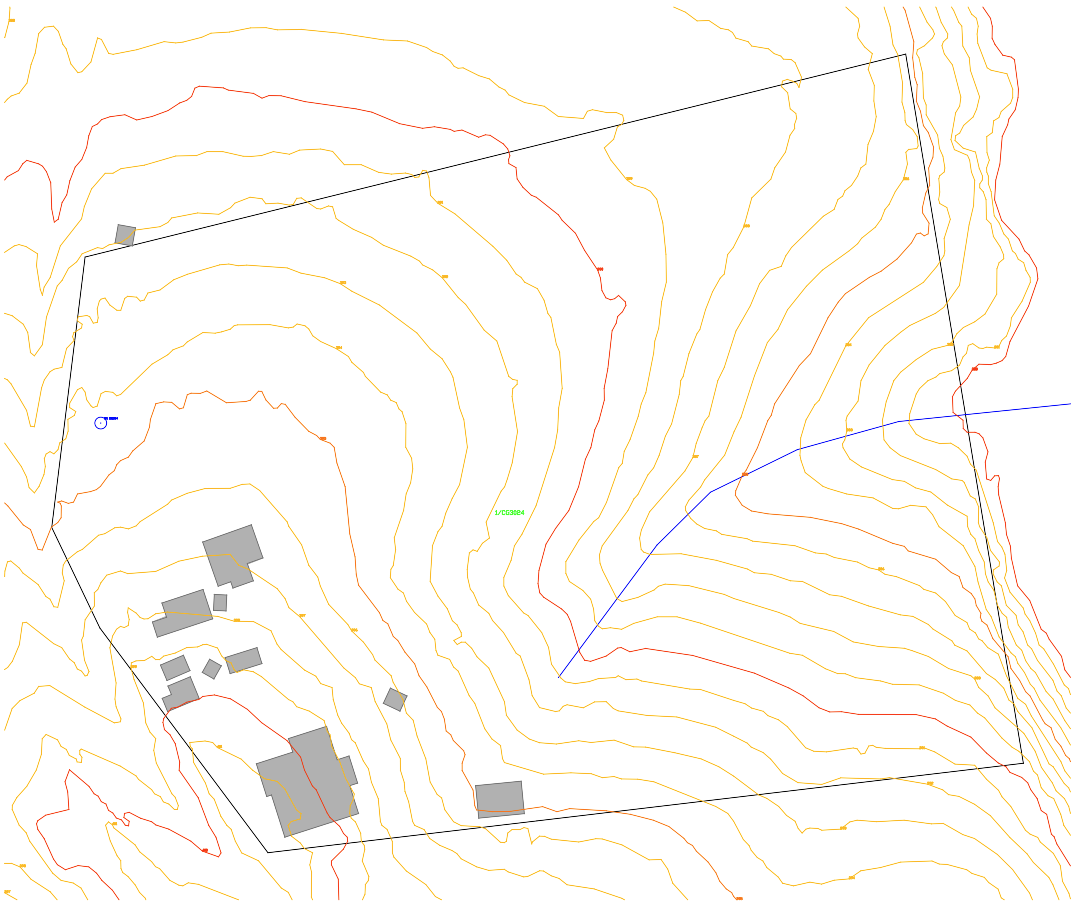
The PlanInsight Site Report is a $29 one off report for a single address that lists the flood, bushfire, landslide, coastal and acid sulfate overlays crossing the lot with the share of the lot each covers, alongside the title details, the zone where the council publishes it, the DA history for the lot, the Bureau of Meteorology 2016 design rainfall table, registered water bores within 500 m and contours. The zip includes a DXF R12 in metres with each overlay on its own layer, so the flood extent lines up with the boundary and the levels.
Mapped overlays are not certificates. The report is compiled from public government and council records and does not replace a planning certificate, a registered survey, a title search or professional advice. For a floor level or an approval, use the council’s flood information and a hydraulic engineer.
Reports are available in Queensland, New South Wales, Victoria, South Australia, Tasmania and the ACT, not Western Australia or the Northern Territory. You confirm the lot on a map before paying, and a report that fails to generate is refunded in full.