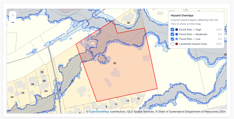
Hazard overlays

Flood and bushfire overlays, on the lot and in your CAD.

Search an address and see which hazard overlays cross the lot and how much of it they cover. Then export them as DXF layers alongside the boundary and contours.

14-day free trial · No credit card · Every layer on every plan

Flood and landslide overlays drawn over a property boundary

What you get

Overlays come from state planning mapping everywhere we cover, and from council flood studies where a council publishes its own.

OVERLAY_FLOOD_*

Flood

Flood planning areas and, where councils publish them, high, moderate and low flood risk bands.

OVERLAY_BUSHFIRE

Bushfire

Bushfire prone land and bushfire hazard areas from state and council planning maps.

OVERLAY_LANDSLIDE

Landslide and steep land

Landslide hazard and steep land overlays where the state or council maps them.

OVERLAY_COASTAL

Coastal

Storm tide, erosion prone and coastal areas where published.

OVERLAY_ACID_SULFATE

Acid sulfate soils

Acid sulfate soil mapping where the state or council publishes it.

Share of the lot affected

Each overlay shows whether it touches the lot and the percentage it covers, on the property page.

What's available in your state

Boundaries work for every address in Australia. The rest depends on what each state publishes.

StateContoursHazard overlaysOther layers
Queensland1 m, 5 m, 10 mFlood, Bushfire, Coastal, Landslide, Steep land, Acid sulfate soils (some councils)Building Outlines, Watercourse, Water Bores
New South Wales10 m, 20 mFlood, Bushfire, Landslide, Acid Sulfate Soils, Coastal managementBuilding Outlines, Watercourse, Water Bodies, Water Bores
Victoria1 m, 10 m, 20 mFlood, Bushfire, LandslideBuilding Outlines, Watercourse, Water Bores
South AustraliaState topographicFlood, Bushfire, Acid Sulfate Soils, CoastalBuilding Outlines, Watercourse, Water Bores
Western Australia2 m, 10 mFlood, Bushfire, Acid Sulfate SoilsBuilding Outlines, Watercourse, Water Bores
Tasmania5 m, 10 mFlood, Bushfire, Landslide, CoastalBuilding Outlines, Watercourse, Pathways & Tracks
Australian Capital TerritoryNot yetFlood, BushfireBuilding Outlines, Watercourse
Northern TerritoryNot yetNot publishedBuilding Outlines, Water Bores, Watercourse

Contours use the finest source available at the lot first. Council flood studies replace the statewide layer where the council publishes one.

Before you open it in AutoCAD

Only what crosses the lot

The DXF includes an overlay layer only when that overlay intersects the lot, so drawings stay clean.

Council studies win

Where a council publishes its own flood mapping, it replaces the broader statewide layer.

A first check, not a certificate

Use it to spot constraints before you quote. Confirm with the council's planning certificate or flood search for approvals.

Questions

How do I check if a property is in a flood or bushfire overlay?

Search the address in PlanInsight. The property page lists every mapped hazard overlay that crosses the lot and the share of the lot it covers, and you can switch each layer on the map.

Can I get the overlays into AutoCAD?

Yes. Download the property DXF and each overlay that crosses the lot comes on its own layer, lined up with the boundary and contours.

Which states are covered?

Queensland, New South Wales, Victoria, South Australia, Western Australia, Tasmania and the ACT. The Northern Territory doesn't publish a queryable hazard service yet. The table above shows the overlay types per state.

Is this the same as a council flood certificate?

No. It's the mapped overlay data councils and states publish, ideal for early checks. For approvals, rely on the council's planning certificate or flood search.

Check the overlays on your next lot.

14-day free trial, no credit card. Plans from $49/mo after that.

Start free trial